Every city has a surface and a depth, a face presented to the world and a foundation on which that presentation depends. In most cities, the relationship between the two is straightforward: beneath the streets lie pipes and cables and the sediment of previous buildings, practical infrastructure and geological accident, interesting to engineers and unremarkable to everyone else. Rome is not most cities. Beneath the streets of Rome, beneath the pavements and the traffic and the monuments and the ruins that are themselves already layers deep in time, there exists a second city of extraordinary complexity, extraordinary antiquity and, in certain of its quarters, extraordinary beauty. A city of galleries and cisterns, of catacombs and quarries, of aqueduct channels still carrying clear water and chambers still bearing the marks of the tools that cut them two thousand years ago. A city to which access is restricted, partial and always provisional. A city that has now, for the first time in its history, been formally counted: over seven thousand distinct underground voids, mapped, numbered and assessed by the scientific institutions of the Italian state.
The Map and What It Tells Us
The Carta delle Cavità Sotterranee di Roma, the Map of Underground Cavities of Rome, has been in the process of compilation since the late twentieth century, but the version published in its most recent and comprehensive iteration by ISPRA, the Istituto Superiore per la Protezione e la Ricerca Ambientale, in collaboration with the CNR, the Consiglio Nazionale delle Ricerche, represents a qualitative advance over all previous surveys. For the first time, a single authoritative document brings together the data gathered by decades of archaeological investigation, engineering surveys, speleological exploration and documentary research into a unified cartographic record that allows the underground city to be apprehended in something approaching its true dimensions.
The figure of over seven thousand registered cavities, which received considerable attention in the Italian press on its announcement, is at once impressive and, in the judgement of the researchers who produced it, almost certainly an underestimate. The map covers the administrative territory of the municipality of Rome, an area of approximately 1,285 square kilometres, of which the historic centre represents only a fraction. Within that area, the density of known underground spaces varies considerably: it is highest in the ancient core of the city, where the accumulated excavations of three thousand years of continuous occupation have produced a palimpsest of subterranean activity of staggering complexity, and it decreases toward the periphery, where the geology changes and the historical record is thinner. The researchers acknowledge explicitly that large sections of the historic centre, particularly those areas beneath private property and beneath the great ecclesiastical complexes that have managed their own subsurface environments independently for centuries, remain incompletely surveyed.
The practical significance of the map is not merely scholarly. Rome is a city where underground voids constitute a genuine engineering hazard: the sinkholes that appear with alarming regularity in the streets and piazzas of the historic centre, swallowing sections of road or the lower floors of buildings with the sudden completeness of a trap opening, are in most cases the surface expression of underground voids that have been present, unknown and unsupported, beneath the urban fabric for generations. The map is therefore simultaneously a historical document of the first importance and an instrument of civil engineering, a tool for understanding both what the city has been and what it is at risk of becoming.
The Geology of a Hollow City
To understand why Rome is so extensively perforated beneath its surface, it is necessary to understand the geological history of the landscape on which the city was built. Rome occupies the left bank of the Tiber within a territory shaped primarily by the volcanic activity of two ancient centres: the Alban Hills to the southeast, whose eruptions over the past six hundred thousand years have deposited successive layers of pyroclastic material across the region, and the Sabatini volcanic district to the northwest, which has contributed additional volcanic sequences to the local geology. The result is a landscape in which the dominant building material from the surface downward is volcanic tuff, the consolidated product of ancient ash falls and pyroclastic flows that cooled and compressed into a rock of variable density but consistent workability.
Roman tuff, specifically the varieties known as tufo lionato and tufo granolare, which underlie the greater part of the historic centre, is a material of considerable practical virtue. When freshly quarried, it is soft enough to be cut with iron tools at a rate that makes large-scale excavation economically feasible. When exposed to air, it hardens progressively over months and years, developing a compressive strength that allows it to sustain the weight of multi-storey masonry structures above it with, in most conditions, adequate reliability. It is also a porous material, which means that it absorbs and retains water, moderating temperature extremes in the spaces carved from it and providing the natural humidity that certain uses of underground space, notably the storage of wine, cheese and other perishables, require. These properties were understood and exploited in Rome from the earliest period of the city's history, and the exploitation of them over three thousand years of continuous occupation is the primary explanation for the density of underground voids documented in the ISPRA map.
A secondary geological factor is the presence of natural cavities within the volcanic sequence itself. The rapid cooling of pyroclastic flows can produce gas-filled voids within the consolidated rock, and the differential erosion of layers of varying hardness by groundwater can enlarge these natural voids over geological time into spaces of considerable size. Several of the cavities recorded in the ISPRA map are of natural origin, subsequently modified by human use or simply discovered and incorporated into the underground network without substantial alteration. The distinction between natural and artificial voids is not always clear from the available evidence, and the map records both without necessarily resolving the question of origin in every case.
The seven hills and their geology: The traditional seven hills of Rome, the Capitoline, the Palatine, the Aventine, the Caelian, the Esquiline, the Viminal and the Quirinal, are not arbitrary geographical features but ridges of harder tuff left standing as the softer surrounding rock was eroded by the Tiber and its tributaries over millennia. The valleys between the hills, filled with alluvial sediment, are geologically distinct from the hilltops and present different engineering challenges: alluvial fills are less stable than consolidated tuff and less suitable for deep excavation. The distribution of underground voids in the ISPRA map reflects this geology closely, with the highest densities concentrated on the tuff ridges and the lowest in the alluvial valleys.
The Republican Quarries: Tuff as the Material of Empire
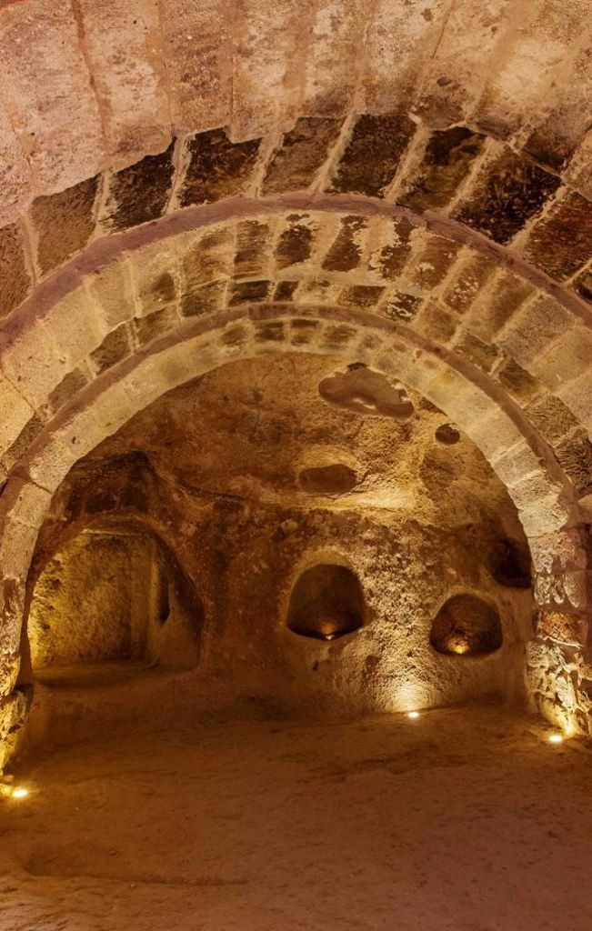
The oldest category of underground void in the ISPRA map, in terms of human origin, is the tuff quarry. From the earliest period of the Roman Republic, and almost certainly from the period of the monarchy that preceded it, the builders of Rome excavated tuff from beneath and adjacent to the city to supply the construction industry with the raw material for walls, foundations, paving stones and the structural elements of the buildings whose remains still define the Roman landscape. These quarries, known generically as caveae or in some sources as antri, were worked by a labour force whose composition changed over time, from free craftsmen in the early Republican period to slave gangs as the supply of enslaved persons from military conquest expanded in the second and first centuries BC.
The organisation of tuff quarrying in Rome was, in its mature Republican form, a complex industrial operation. The stone was extracted in regular blocks of standardised dimensions, sized to match the construction requirements of the period: the opus quadratum technique of laying large ashlar blocks in regular courses, which characterises the most substantial Republican buildings visible today, required blocks of specific dimensions that the quarry workers cut to order. The galleries that resulted from this systematic extraction are therefore not the irregular tunnels of mineral mining but rooms of relatively consistent geometry, whose walls, ceilings and floors bear the regular marks of the iron picks and chisels used to detach successive layers of stone. Many of these marks are still visible in the quarry galleries that have been documented beneath the historic centre, preserved in the darkness and the stable conditions of the underground environment with a fidelity that makes them among the most direct surviving records of Roman craft practice.
The quarries beneath the Caelian, the Aventine and the Oppian hills are among the most extensively documented, and their extent, as revealed by successive archaeological investigations over the past century and a half, gives some sense of the scale of the extraction that supplied Rome's construction requirements during the centuries of its most rapid growth. Individual quarry systems extend horizontally for hundreds of metres beneath their respective hills, their galleries branching and intersecting in a pattern that reflects the progressive exploitation of the tuff deposit as successive generations of workers followed the most accessible seams. In some areas, the galleries are stacked vertically in two or three levels, the upper quarries predating the lower ones as the surface deposit was exhausted and the extraction went deeper.
What happened to the quarries after the stone had been removed is a question of considerable archaeological interest. The evidence suggests that most were not immediately backfilled but were left open and subsequently adapted for secondary uses that evolved over the centuries of the city's history. Storage of agricultural produce, particularly wine and olive oil in the natural coolness of the underground environment, was among the earliest secondary uses, documented from the Republican period. The quarry galleries beneath the Caelian hill were used, at various points in their post-extraction history, as Christian meeting spaces in the period of the persecutions, as water cisterns, as cellars for the ecclesiastical institutions that occupied the hill above, and as refuge spaces during the periodic sieges and invasions that punctuated Rome's medieval history. This layering of successive uses within a single underground space over a period of two thousand years is characteristic of the most complex elements of Rome's subterranean archaeology.
The Aqueducts: Water as the Engineering of Civilisation
No aspect of Roman civil engineering has been more extensively studied, more enthusiastically celebrated and more persistently misunderstood than the city's water supply system. The popular image of the Roman aqueduct is an elevated structure of repeated arches crossing the Campagna in a straight line: grand, photogenic and thoroughly misleading as a representation of the system as a whole. The arched sections of the Roman aqueducts, remarkable as they are as feats of engineering and as elements of the landscape, represent only a small fraction of the total length of the supply channels. The majority of the water in any given aqueduct travelled not through the air but underground, in tunnels cut through the rock of the hills and sealed passages beneath the city streets, invisible to the surface world and largely invisible to the historical record until the detailed surveys of recent centuries.
Rome was served, at the height of the Imperial period, by eleven major aqueducts whose combined capacity delivered an estimated one million cubic metres of water to the city every day, a figure that works out to approximately one thousand litres per person per day for a population of one million, a per capita supply that the city of Rome did not regain until the twentieth century. These eleven aqueducts drew water from springs and rivers in the hills east and southeast of the city, carried it across distances ranging from fifteen to ninety kilometres, and distributed it through a network of lead and terracotta pipes to the fountains, baths, private houses and industrial facilities that defined the quality of urban life in Imperial Rome.
The underground sections of these channels, and the cisterns, distribution tanks and settling basins that formed part of the supply infrastructure, constitute a substantial portion of the underground voids documented in the ISPRA map. Several of the aqueducts continued to supply water to Rome through the medieval period and beyond: the Acqua Vergine, the Virgin Water, is the most notable example. Constructed between 19 and 33 BC under the direction of Marcus Vipsanius Agrippa, the son-in-law and principal general of the Emperor Augustus, the Acqua Vergine drew its water from springs in the Salone area to the northeast of the city and delivered it to the Campus Martius through a channel that followed a gently descending route of approximately twenty-one kilometres. Unlike most of the other aqueducts, which fell out of use after the disruption of their supply lines by the Ostrogothic wars of the sixth century AD, the Acqua Vergine survived because its underground course was more resistant to the military damage that ended the functioning of the elevated aqueducts. It has supplied water to Rome continuously, in one form or another, ever since its construction, and it is the same source that feeds the Trevi Fountain today.
The Vicus Caprarius: An Aqueduct Beneath the Trevi Fountain
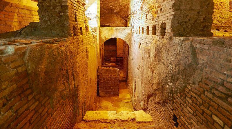
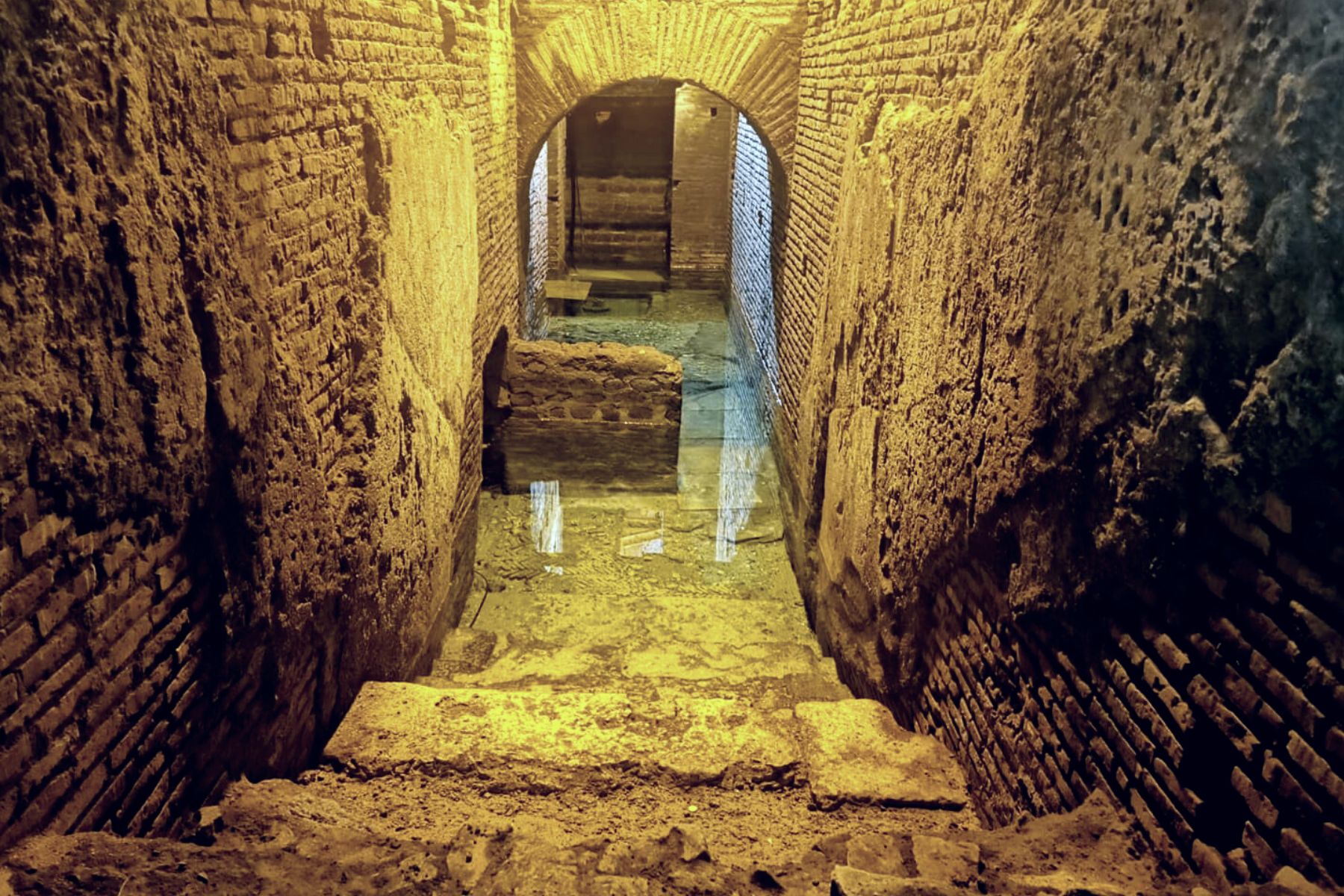
Of all the underground spaces in Rome that are regularly accessible to visitors, the Vicus Caprarius, the City of Water, is among the most concentrated in its archaeological significance and the most surprising in its urban context. The site lies beneath the streets of the Trevi district, a few tens of metres from the most visited monument in Rome, in a space discovered during renovation works in the late 1990s and subsequently developed as an archaeological museum of the most immediate and unmediated kind: a descent through the floor of a modern building into an ancient world that the renovation works had interrupted in mid-process.
The Vicus Caprarius preserves, within a relatively small underground area, an extraordinary concentration of Roman urban archaeology. A substantial section of the channel of the Acqua Vergine, the same aqueduct that supplies the Trevi Fountain above, runs through the site in its original Roman form: a vaulted tunnel of brick-faced concrete, its interior coated with the waterproof opus signinum plaster that the Romans used to seal hydraulic structures, still in visibly good condition after two thousand years of continuous use. Adjacent to the aqueduct channel, the remains of a substantial Roman domus, an urban dwelling house of the second or third century AD, include walls standing to several metres in height, decorated with traces of painted plaster, and a cistern of considerable size that collected water from both the aqueduct supply and the roof drainage of the house above.
What makes the Vicus Caprarius particularly valuable as an archaeological site, beyond the intrinsic quality of its remains, is the clarity with which it illustrates the relationship between the Roman water supply infrastructure and the private domestic architecture that depended on it. The proximity of the aqueduct channel to the cistern of the domus, and the evidence of the connection between them, shows in physical terms what the written sources describe in general terms: that private access to aqueduct water in Roman cities was a privilege granted to property owners who paid a specific fee to the administration of the water supply, and that the physical infrastructure of this access was integrated directly into the architecture of the houses concerned.
The site is open daily to visitors and offers guided tours in multiple languages. The entrance is through a door that opens, from the street level above, into a staircase descending to the archaeological level, and the transition from the noise and the crowding of the Trevi district above to the cool, quiet, stone-walled space below takes approximately thirty seconds and approximately two thousand years. It is one of the most abrupt temporal dislocations available in any city, and one of the most effective introductions to what Rome's underground world actually consists of.
The Trevi Fountain and the Acqua Vergine: The water that falls into the Trevi Fountain and that visitors toss their coins into in the expectation of a return to Rome is the same water that flows through the Acqua Vergine channel visible at the Vicus Caprarius a few metres away. It has been flowing through essentially the same route, from the springs at Salone to the Trevi district, for over two thousand years. The fountain itself, designed by Nicola Salvi and completed in 1762, is the terminal point and the most theatrical expression of a hydraulic infrastructure that long predates it and will, in all probability, long outlast it.
The Catacombs: The Geography of Early Christian Faith
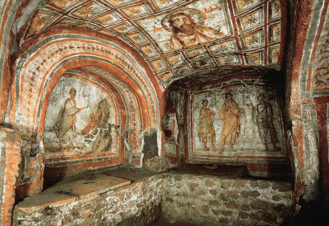
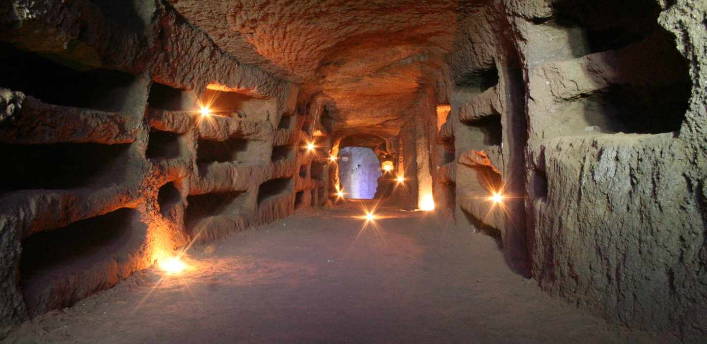
The word catacomb derives from the Greek kata kymbas, near the hollow, a topographical description of the area along the Via Appia where the most extensive early Christian burial complex was established, and which gave its name eventually to all such underground cemeteries regardless of their location. The catacombs of Rome are the most extensive surviving example of a funerary practice that was widespread across the ancient Mediterranean world but that found its fullest and most elaborate expression in the Christian communities of the capital of the empire from the second century AD onward.
The geological conditions that produced the Republican tuff quarries also produced the conditions for catacomb construction. Tuff, as previously noted, is workable with simple iron tools, and the galleries of the catacombs were cut by teams of specialist workmen known as fossores, diggers, who worked in the confined space of the developing tunnels by lamplight, extending the gallery network systematically outward and downward from the initial access points as the community's burial requirements grew. The characteristic form of a catacomb gallery is a tunnel of modest width, typically sufficient for two workers abreast, with the walls cut away at regular intervals to create the horizontal niches, loculi, in which individual burials were laid and then sealed with tiles or slabs of marble bearing the name of the deceased, sometimes a simple epitaph, and occasionally a painted image.
The Christian catacombs of Rome extend beneath the suburban territory outside the ancient city walls in a belt that follows the principal roads leading out of the city: the Via Appia, the Via Ardeatina, the Via Latina, the Via Nomentana and others. The largest complex, the Catacombe di San Callisto on the Via Appia, covers an area of approximately fifteen hectares and comprises some twenty kilometres of galleries on four levels, with an estimated total of half a million burials accumulated over the two and a half centuries of the complex's active use between approximately 150 and 400 AD. The Catacombe di Priscilla on the Via Salaria, the Catacombe di Domitilla on the Via Ardeatina and the Catacombe di San Sebastiano on the Via Appia are among the other major complexes, each of comparable extent and complexity. Together, the major catacomb systems of Rome contain a total gallery length estimated at between 150 and 180 kilometres, a figure that places them among the most extensive underground architectural complexes ever constructed.
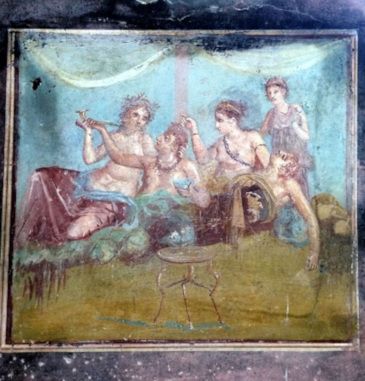
Within the galleries, the decorative programs of the Christian catacombs represent the earliest substantial body of surviving Christian figurative art. The painted images that adorn the arched chambers, cubicula, of the wealthier burials depict scenes from the Old and New Testaments, symbolic images of fish, doves, the chi-rho monogram and the anchor, portraits of the deceased in the Roman tradition, and pastoral scenes whose imagery of the Good Shepherd draws on the same visual tradition of Roman bucolic art while investing it with specifically Christian theological significance. These paintings are fragile, vulnerable to atmospheric change and to the biological activity of the microorganisms that inhabit the humid underground environment, and their conservation is an ongoing challenge of considerable technical complexity.
The Underground Lakes and the Temple of Claudius
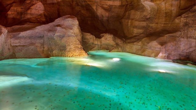
Among the most remarkable elements of Rome's underground world, and among those least accessible to the general visitor, are the perennial water bodies that exist within certain underground spaces: pools and lakes of groundwater filtered through the volcanic rock and accumulated in the natural and artificial voids of the subsurface, their surfaces often of a clarity and a stillness that has struck every observer who has encountered them as possessing an almost supernatural quality of preserved silence.
The most documented of these underground water bodies are those accessible beneath the Caelian hill, in the complex of voids that lies beneath and adjacent to the area of the Temple of Claudius. The Temple of Claudius, the great sanctuary constructed by the Emperor Nero in honour of his deified predecessor and subsequently converted into the precinct of the Villa Celimontana, occupied the northern summit of the Caelian and was supported by a massive platform of concrete and tuff fill that created, in the spaces beneath its vaulted substructures, a series of large chambers of considerable architectural quality. These chambers, cut into the tuff of the hill and reinforced with concrete vaulting of Roman construction, were used in antiquity as storage and service spaces for the temple complex above, and in the medieval period they formed part of the water infrastructure of the ecclesiastical institutions that occupied the Caelian.
Within the deepest of these chambers, at a level several metres below the surface of the modern street, groundwater has accumulated over centuries in pools of extraordinary clarity. The water is filtered by its passage through the volcanic tuff, which acts as a natural purification medium removing suspended particles and most biological contaminants, and it emerges into the underground chambers at a temperature that remains essentially constant throughout the year, between fourteen and sixteen degrees Celsius regardless of the season above. The pools are perennial, their level maintained by the continuous recharge from the surrounding rock, and they have been in existence, in their present form, for at least several centuries and probably much longer.
The visual quality of these underground lakes, in the conditions of the limited artificial lighting that has been installed in the accessible sections of the system, is genuinely extraordinary. The water surface, perfectly still in the absence of any current or disturbance, reflects the vaulted ceiling above it with a fidelity that confuses the distinction between the real space and its reflection, creating a visual experience that the limited vocabulary of architectural description is ill-equipped to capture. Visitors who have been admitted to these spaces in the context of guided tours organised by the archaeological institutions responsible for the Caelian consistently describe the experience in terms that suggest its impact is considerably in excess of what the objective description of a pool of water in a dark room might prepare one to expect.
There is a quality of attention that underground spaces impose on those who enter them that surface spaces rarely demand: a slowing of the pace, a heightening of the senses, an awareness of the weight and the age of the material above. To stand beside an underground lake in a Roman chamber cut two thousand years ago, and to understand that the water at your feet has been accumulating there, filtering through the same volcanic rock, for a period of time that makes the building above it seem recent, is to experience the particular vertigo of deep historical time that Rome, more than almost any other city, provides with such persistent and such lavish generosity.
The Mithraeum of Santa Prisca and the Hidden Sanctuaries
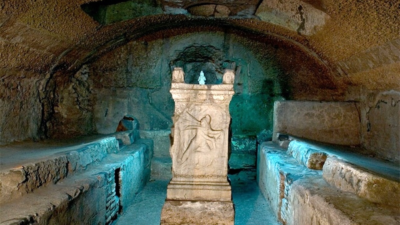
Not all of Rome's underground spaces were quarries or aqueducts or tombs. Some were places of worship for the mystery cults that flourished in the Imperial period alongside the public religion of the state and the private devotions of the household. Among these, the cult of Mithras, a Persian divinity whose worship spread across the Roman empire in the first and second centuries AD, left behind some of the most remarkable subterranean sanctuaries ever discovered, and the finest of them is preserved beneath the Basilica of Santa Prisca on the Aventine Hill.
The Mithraeum beneath Santa Prisca was discovered in 1934 during excavation work directed by the archaeologists of the Pontifical Commission for Sacred Archaeology, and what they found was a sanctuary of exceptional completeness and exceptional artistic quality. The central chamber of the mithraeum, a long vaulted room cut into the tuff of the Aventine, preserves the original painted plaster decoration on its walls and ceiling almost intact, a program of images that includes the tauroctony, the central cult scene of Mithraic religion depicting the god Mithras slaying the bull, together with processions of the two torchbearers Cautes and Cautopates, zodiacal symbols, and a series of ritual inscriptions whose content and arrangement have occupied scholars of Mithraic studies for decades. The cult statue itself, a marble group of considerable quality, remains in situ, and the ritual benches where the initiates reclined for the sacred meal are still visible on either side of the central aisle.
The Mithraeum of Santa Prisca is not regularly open to the public in the manner of the catacombs or the Vicus Caprarius. Access is granted through advance booking, and visits are organised by the Augustinian friars who manage the basilica above, typically on Saturday mornings and by appointment. The number of visitors who have seen this underground sanctuary in the ninety years since its discovery is therefore a fraction of the number who have visited the more accessible sites, and the experience of descending into its vaulted silence, of standing before the tauroctony in the dim electric light that has replaced the oil lamps of the ancient worshippers, is correspondingly more precious. There is a quality of preserved ritual intention in this space that the more crowded sites cannot replicate, a sense that the act of worship performed here for two centuries has left a residue in the stone that no amount of time can entirely erase.
Other Mithraea survive elsewhere in Rome: beneath the Basilica of San Clemente, whose mithraeum is integrated into the multilevel archaeological sequence accessible to all visitors, and beneath the Circus Maximus, where a sanctuary of modest size but considerable interest was uncovered during the construction of the metro. But the Mithraeum of Santa Prisca is the jewel of the collection, and for those who are willing to plan ahead and to make the necessary arrangements, it offers an encounter with the religious underground of Imperial Rome that is as immediate as it is unforgettable.
Recent Sinkholes and the Silent Threat Beneath the Pavements
The abstract risk of sinkholes, so easily dismissed in the reading, becomes concrete and alarming when one examines the catalogue of recent collapses that the municipal authorities of Rome have been obliged to document. In December 2020, a sinkhole opened in the Via Ruggero Bonghi in the Prenestino district, swallowing a Fiat Panda and a section of the roadway that required several weeks to repair. In February 2021, a larger collapse occurred in the Parco dei Ravennati in the Tor Bella Monaca area, opening a crater approximately ten metres wide and six metres deep that exposed a previously unknown underground cavity of considerable extent. In May 2022, a sinkhole appeared in the courtyard of a residential building in the Monteverde district, forcing the evacuation of the building and the demolition of one of its wings. And in November 2023, a particularly spectacular collapse opened in the Via Giulia, one of the most beautiful Renaissance streets in the historic centre, swallowing the cobblestones and part of the pavement directly in front of the Palazzo Farnese, now the French Embassy.
These events are not isolated accidents. The ISPRA map, for all its incompleteness, has allowed the correlation of sinkhole locations with the known distribution of underground cavities, and the correlation is unambiguous: the vast majority of Roman sinkholes occur in areas where the density of mapped cavities is highest, and where the age of those cavities, combined with the progressive decay of their structural integrity over centuries of neglect, makes collapse not a matter of possibility but of probability. The water infiltration that erodes the tuff from within, the vibration of traffic that shakes the weakened vaults, the loading of the surface with increasingly heavy buildings and increasingly frequent events: all of these factors combine to produce a situation in which the question is not whether a given street will collapse but when.
The response of the municipal engineering services to this situation has been, within the constraints of available resources, adequate and improving. The ISPRA map is now a living document, updated as new cavities are discovered and as existing ones are stabilised or filled. The use of ground-penetrating radar and other non-invasive survey techniques has become standard practice before major construction projects in sensitive areas. And a programme of structural reinforcement, focusing on the most dangerous cavities in the most densely occupied quarters, has been underway since the mid-2010s with results that are measurable but not yet comprehensive. The traveller who walks the streets of Rome today is not walking on a city that has ignored its underground problem; she is walking on a city that has begun to address it, but that faces a problem of such magnitude that a generation of work will not suffice to complete the task.
For the visitor, the practical implication of the sinkhole risk is minimal. The collapses are rare enough, and the areas most at risk are monitored closely enough, that the likelihood of encountering one during a stay of normal duration is vanishingly small. But the awareness that the risk exists, that beneath the pavement of the Via Giulia or the courtyard of a residential building in Monteverde the stone is not as solid as it once was, adds a new dimension to the experience of walking through Rome. The city is not only deep; it is also fragile. And its fragility, like its depth, is a thing that deserves to be known.
Practical Information for Visitors: Hours, Tickets and What to Wear
The underground sites of Rome are not uniform in their opening hours, their admission prices or their accessibility requirements, and the visitor who wishes to see more than one of them is well advised to plan carefully. The Vicus Caprarius, the City of Water beneath the Trevi district, is open daily from ten in the morning until six in the evening, with the last admission at five-thirty. The ticket price is approximately four euros, and the price includes the guided tour, which is offered in Italian and English and lasts approximately forty-five minutes. No advance booking is required for individuals, but groups of more than ten persons should reserve by email.
The Basilica of San Clemente, with its three archaeological levels descending from the twelfth century to the first, is open Monday through Saturday from nine in the morning until twelve-thirty in the afternoon, and again from three in the afternoon until six in the evening. On Sunday, the basilica is open from noon until six in the evening. The ticket for the archaeological excavations is approximately ten euros, and the visit is self-guided, with information panels in multiple languages. The descent to the lowest level involves a steep staircase of more than fifty steps, and there is no lift.
The catacombs of San Callisto on the Via Appia are open from nine in the morning until noon, and again from two in the afternoon until five in the evening, closed on Wednesdays. The ticket price is approximately eight euros, and the visit is by guided tour only, with tours departing every half hour in season. The Catacombs of San Sebastiano, Priscilla and Domitilla operate on similar schedules, with variations that the visitor should confirm on the official websites before setting out.
What to wear is a question that visitors consistently underestimate. The temperature in the catacombs and in the quarry galleries beneath the Caelian and the Aventine remains constant throughout the year, between fourteen and sixteen degrees Celsius, which is to say between fifty-seven and sixty-one degrees Fahrenheit. A sweater or a light jacket is therefore necessary even during the hottest Roman summer, when the surface temperature may exceed thirty-five degrees. Comfortable walking shoes with non-slip soles are also strongly recommended, as the underground floors are often uneven, damp and occasionally slippery. The catacombs are sacred spaces, and the guardians of these sites ask visitors to dress modestly, covering shoulders and knees, as a sign of respect for the religious function these spaces still hold. A woman in a sleeveless dress and shorts will be turned away at the entrance, as I have seen with my own eyes on more than one occasion, and the disappointment of that moment is entirely avoidable.
Accessibility for visitors with mobility difficulties varies considerably from site to site. The Vicus Caprarius has made significant efforts in recent years and is accessible to wheelchair users, with a lift from the street level to the archaeological floor. San Clemente, however, involves a descent of more than fifty steps with no lift alternative, and the same is true for the catacombs, where the ancient galleries are narrow and the walking surfaces are uneven. Visitors with mobility difficulties should contact each site in advance to discuss the specific conditions and to arrange whatever assistance may be available. The underground world of Rome is not uniformly accessible, but some of its treasures are within reach of almost everyone.
The Unstable City: Sinkholes, Collapses and the Modern Risk
The same underground network that constitutes one of the most extraordinary archaeological and geological legacies in the world also constitutes one of the most persistent engineering challenges in the management of a modern city. Rome's sinkholes, the voragini that appear with dramatic suddenness in the streets and occasionally in the interiors of buildings, are a well-documented and recurrent phenomenon whose frequency has increased in recent decades as the combination of ageing underground infrastructure, altered groundwater patterns and the vibration generated by increasingly heavy urban traffic acts upon an underground fabric that was not designed to sustain indefinite neglect.
The typical mechanism of a Roman sinkhole is the progressive erosion of the tuff walls and ceiling of an underground void by water infiltration, leading eventually to a collapse that propagates upward through any superficial fill layers above the void until it reaches the surface. The process is rarely instantaneous: in most cases, the evidence of incipient collapse, in the form of surface cracking, slight subsidence and the appearance of moisture on nearby walls, precedes the opening of the sinkhole by hours or days. When the monitoring is adequate, as it increasingly is in the most densely occupied areas of the historic centre where the ISPRA mapping data informs the work of the municipal engineering services, these precursors can be identified and the area evacuated before structural failure occurs. When the monitoring is absent, as it still is in many areas of the city where the underground cavity map remains incomplete, the collapse arrives without warning.
The relationship between the archaeological value of the underground spaces and the engineering requirement to stabilise them against collapse is one of the most complex challenges facing the institutions responsible for the conservation of Rome. The standard engineering response to a dangerously unstable underground void, which is to fill it with injected concrete or to demolish it in a controlled manner from the surface, is in most cases archaeologically unacceptable. The result is a negotiation, conducted case by case, between the competing demands of safety and conservation that satisfies neither side completely and that the frequency of new discoveries continually reopens.
What Remains Unknown and What Remains Accessible
The publication of the updated ISPRA map with its figure of over seven thousand registered cavities is, paradoxically, most significant not for what it documents but for what it does not. The researchers are explicit: the map is incomplete. The actual number of underground voids beneath Rome is unknown, and the best current estimate is that the known figure represents a substantial fraction, but not the entirety, of what exists. The areas of greatest remaining uncertainty include the densely occupied historic centre, where the combination of private ownership, active urban use and the sheer depth and complexity of the accumulated archaeological record makes systematic survey extremely difficult; the major ecclesiastical complexes, which have historically managed their own subsurface environments and have not always been forthcoming in sharing that information with civil authorities; and the peripheral areas of the municipality, where the combination of rapid twentieth-century development and inadequate archaeological survey has produced a landscape whose underground character is poorly understood.
What is accessible to the interested visitor is a selection from the map's contents that is at once remarkable in its quality and frustratingly small in its proportion to the whole. The Vicus Caprarius and its aqueduct section; the major catacombs of the Via Appia managed by the Salesians and the Pontifical Commission for Sacred Archaeology; the multi-level site of San Clemente in the Lateran district, where three successive phases of building from the first to the twelfth century are accessible on three descending levels including a first-century Roman insula and a Mithraic sanctuary in its basement; the underground areas of the Basilica dei Santi Giovanni e Paolo on the Caelian; the hypogeum of the Aurelii on the Viale Manzoni, with its extraordinary and still partially enigmatic fresco cycles of the early third century: these are among the most significant and most accessible elements of an underground world whose full extent will not be known in any of our lifetimes.
What the ISPRA map has done, beyond its immediate practical utility, is to make the invisible visible in cartographic form, to give a number and a spatial representation to what every Roman, and every attentive visitor to Rome, has always felt but rarely been able to quantify: the sense that beneath the city's surface, beneath the layers of the visible past, there is another city still, patient and dark and full of the things that time has chosen to preserve rather than to destroy. Seven thousand documented spaces. An unknown number more. The city continues downward in every direction, and the counting has only just begun.
A Traveller's Final Consideration
I have walked the streets of Rome for many years, and I have descended into its underground spaces on as many occasions as the permissions and the opportunities have allowed. What I have learned, across those years and those descents, is that the city above and the city below are not two cities but one, and that the separation between them is an illusion produced by the accident of which level one happens to occupy at a given moment. The stone of the Colosseum is the stone of the quarries beneath the Caelian. The water of the Trevi Fountain is the water of the Acqua Vergine, flowing through the same channel that Agrippa built. The faith that built the great basilicas is the faith that carved the catacombs and painted their walls with images of resurrection and deliverance. Rome is a single organism, surface and depth, and to know only the surface is to know less than half of what the city has to teach.
The traveller who comes to Rome with a plan that includes only the monuments above ground has not been deceived; those monuments are among the greatest achievements of human civilisation, and they reward attention without limit. But the traveller who comes with the curiosity to descend, to step through the door in the floor of a modern building into the vaulted silence of an aqueduct tunnel or a quarry gallery or a catacomb corridor, will carry away something that the surface alone cannot provide: a sense of the weight of time, of the persistence of human intention across centuries, of the strange and moving beauty of spaces that were never meant to be seen by the light of day. That sense is the true gift of Rome's underground world, and it is a gift that remains available, in certain places and at certain hours, to anyone who makes the effort to receive it.
Book your transfer from Fiumicino or Ciampino, arrive in Rome without the stress of navigating the train system or negotiating with taxi drivers at the rank, and give yourself the time and the energy that the underground deserves. The city is waiting for you, both above and below. The descent is short, and the silence at the bottom is older than empires.

Comments
No comments yet. Be the first to share your thoughts!
Leave a Comment
Your comment will appear after moderation.