Milan is a city of waterways which have been conquered, celebrated — and lost. When Milan had its full network of canals, it was possible to step into a boat at the centre of the city and sail, without once leaving navigable water, all the way to Venice via the river port of Pavia. The marble for the Duomo arrived this way. So did the coal that heated the city, the timber that built its palaces, and the wine that filled its taverns. For six hundred years, the Navigli — Milan's extraordinary system of artificial waterways — were the engine of the city's economy, its primary means of heavy transport and one of the greatest feats of hydraulic engineering in medieval Europe.
Mediolanum: The City Built in the Midst of Many Waters
Long before Rome arrived, the ancient Insubri people had understood something fundamental about this particular piece of the Po Valley: the ground here was extraordinary. In the 4th century BC, the Insubri chose the location for their principal city with the precision of engineers — a site where the water table was close to the surface, where natural springs fed into a network of streams, where the flat alluvial plain offered both fertile farmland and defensible approaches from every direction.
They called the city Medhelan — a name of Celtic origin most scholars interpret as "the middle of the plain" or, more poetically, "the middle of many waters." When the Romans arrived and renamed it Mediolanum, they preserved the essential meaning: a city positioned between water courses, drawing its identity from its relationship with the water around and beneath it.
"Milan stood in the midst of many waters — and the name Mediolanum indicated its intermediate position between the streams."
The marble miracle of the Duomo: Construction of the Milan Cathedral began in 1386 and required millions of blocks of Candoglia marble quarried on Lake Maggiore, 80 km to the north. The Naviglio Grande made this possible — the barges loaded at Candoglia crossed the lake, entered the Naviglio Grande and arrived at the ancient dock in the heart of Milan. Without the canal, the Duomo as we know it could not have been built.
Leonardo da Vinci and the Engineering of Water
In 1482, a thirty-year-old painter and engineer from Florence arrived in Milan with a letter of introduction to Ludovico Sforza, Duke of Milan. Leonardo da Vinci stayed in Milan for seventeen years. During this period he painted the Last Supper and the first version of the Virgin of the Rocks, but he also spent an extraordinary amount of time thinking about, studying and redesigning the city's canal system. His notebooks from the Milan years contain hundreds of drawings related to hydraulics: lock designs, water wheels, dredging machines, canal profiles and proposals for extensions.
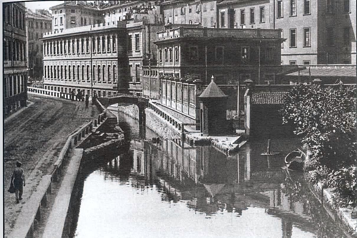
Leonardo's key contribution was the mitre lock — a chamber with two sets of angled gates that could be opened and closed to raise or lower the water level within, allowing a boat to ascend or descend between canal levels. The mitre lock he designed for the Naviglio della Martesana was so efficient that locks built to essentially the same principle are still used on canals worldwide today.
The only surviving lock from Leonardo's Milan remains partially visible at the Conca dell'Incoronata — a 15th-century lock chamber near Corso Garibaldi in the north of Milan's historic centre. The structure, now dry, gives the clearest impression of how the lock system worked. It is one of the most undervisited historical sites in the city.
"Water is the driving force of all nature." — Leonardo da Vinci, Notebooks, c. 1490s
A City Afloat: Commerce, Locks and the Life of the Canals
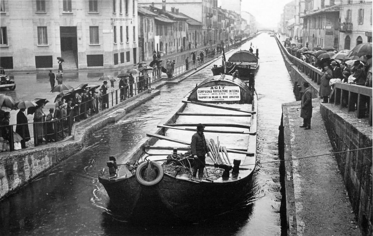
By the late 18th century, the Navigli network connected Milan to almost every major city and town in the Po Valley. The towpaths — the flat roads running alongside the canal banks — were among the most important infrastructure in Lombardy. Teams of horses and oxen walked them constantly, hauling barges upstream against the current.
The efficiency of water transport: A single horse pulling a barge on a canal could move up to four tons of cargo — the equivalent of what twenty-seven horses could carry on the road simultaneously. As late as 1929, more goods moved through Milan by water than by road.
The passenger boats — the barcacce — added another dimension to the canal's social life. Regular services connected Milan to Pavia, to Lodi, to Vigevano and to dozens of smaller towns. For centuries, the canal was not just a commercial artery but a public transport system.
The Slow Disappearance: How a City Lost Its Water
The decline of the Navigli was not an event but a process — a long, gradual erosion of relevance that accelerated catastrophically in the early 20th century. It was driven by three forces: the railway, the automobile and the growing crisis of urban hygiene.
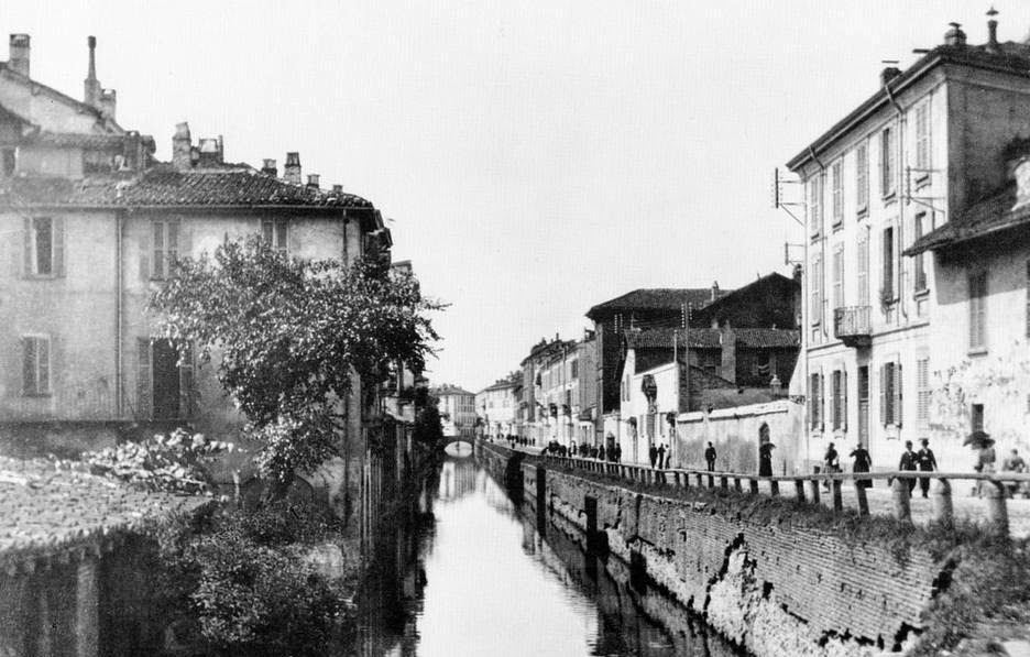
By the late 19th century, the inner canals of Milan had become severely polluted. Industrial effluent, domestic waste and the ordinary run-off of an expanding industrial city had turned what had once been navigable waterways into open sewers. The stench in summer was a constant subject of public complaint.
The great covering of 1929: The decision to fill and cover the inner ring of Milan's Navigli was taken by the Fascist administration in the late 1920s. Within a year the Naviglio Interno had been converted into the roads now called Corso di Porta Ticinese, Via Molino delle Armi, Via Arena and Via Circo. The covering destroyed one of the most extraordinary urban waterscapes in Europe and replaced it with arterial roads that are now permanently congested.
Underground Milan: What Flows Beneath the Streets
When the Navigli were covered, they were not demolished. They were buried. The canal beds were paved over, the walls remained in place, and the water — where it still flowed — was redirected into the sewer system or allowed to continue through the covered channels underground.
A significant portion of the original Navigli network still exists beneath the streets of central Milan. The cerchia dei Navigli — the inner ring canal — exists largely intact beneath the roads that replaced it, incorporated into the drainage infrastructure but physically unchanged. The brick vaults and stone walls that the Visconti engineers built in the 14th and 15th centuries remain precisely where they have always been, carrying water in the dark beneath the traffic above.
In 1868, customs officers descended into the covered section of the canal network and found a fully operational smuggling operation: a secret boat, hauled through the underground waterways by a rope, carrying meat, alcohol and dutiable goods directly into the city centre, bypassing every customs checkpoint.
Porta Ticinese and What Remains of the Water City
The most powerful reminder of Milan's water identity is found at Porta Ticinese — the ancient southern gate of the medieval city, which once stood at the junction of two canals: the Naviglio Grande arriving from the west and the Naviglio Pavese departing south toward Pavia.
The Naviglio Grande and the Naviglio Pavese — the two canals that survived 1929 intact — remain navigable and fully visible. Their banks have been transformed into one of Milan's most vibrant cultural and nightlife districts, lined with restaurants, galleries, wine bars and the studios of artists and designers who have colonised the old canal-side warehouses.
Every last Sunday of the month, the Alzaia Naviglio Grande hosts the Mercatone dell'Antiquariato — a famous antiques market stretching for hundreds of metres along the canal bank, with over 400 dealers selling furniture, paintings, books and objects from every period of Italian history.
The Springs, the Meadows and the Song from Via Gluck
Milan's relationship with water was not limited to its canals. The groundwater of the Po Valley plain was, in the ancient and medieval city, close to the surface — feeding natural springs (fontanili) that emerged from the ground throughout the urban area, maintaining temperatures above 10°C year-round regardless of season.
"Il Ragazzo della Via Gluck": In 1966, Adriano Celentano released one of the most famous Italian pop songs of the century — Il Ragazzo della Via Gluck. The song tells of a boy who grew up in the countryside on the edge of the city, where there were green fields and streams, and returns to find it all built over. It became the anthem of a generation that had watched the marcite — the last green water meadows of old Milan — disappear under concrete in the postwar urban expansion.
Could Milan Recover Its Water? The Case for the Navigli
The argument for restoring Milan's inner Navigli is not purely nostalgic. There is a practical case: a canal boat carrying four tons of material still consumes a fraction of the energy of the equivalent truck journey. In a city permanently choked by traffic and consistently failing its air quality targets, a restored canal that could carry bulk construction materials by water rather than by road would remove thousands of heavy vehicle movements from the city's arteries every year.
A feasibility study completed in the 2010s concluded that approximately 2.8 km of the historical inner canal could be restored. The project faces enormous obstacles: utility networks, metro tunnels, the cost of relocating underground infrastructure and the loss of road capacity. As of 2026, it remains an aspiration rather than a plan, but it is an aspiration that never entirely disappears from Milan's urban conversation.

Comments
No comments yet. Be the first to share your thoughts!
Leave a Comment
Your comment will appear after moderation.